




**
Overview
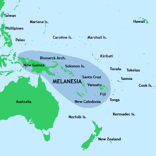
Melanesia stretches across a vast swath of the southwestern Pacific Ocean, covering an area of roughly 2.5 million km² and home to more than 12 million inhabitants. The region’s name—derived from the Greek words melas (black) and nesos (island)—was coined by 19th‑century European explorers to describe the dark‑skinned peoples who inhabit its islands. Today, Melanesia includes New Guinea (the world’s second‑largest island, split between Indonesia and the independent state of Papua New Guinea), the Bismarck Archipelago, the Solomon Islands, Vanuatu, New Caledonia, and the Fiji Islands, as well as smaller groups such as the Torres Strait Islands and the Arafura Sea islands.Geographically, the region is a tapestry of towering volcanic peaks, dense tropical rainforests, limestone karsts, and coral atolls. Its climate is predominantly tropical, with high humidity and abundant rainfall supporting some of the planet’s most diverse ecosystems. Melanesian seas teem with marine life, while the islands themselves harbor endemic birds, mammals, and plant species found nowhere else. Culturally, the area is a linguistic powerhouse: over 1,300 distinct languages—the highest density of languages per unit area in the world—are spoken, reflecting millennia of isolated development and intricate social structures.
History/Background
Human settlement in Melanesia dates back at least 45,000 years, when Austronesian and Papuan peoples migrated across the Pacific, bringing with them sophisticated seafaring technologies and agricultural practices. By the first millennium CE, complex chiefdoms and trade networks linked islands, exchanging obsidian, shells, and woven textiles. European contact began in the 16th century, when Portuguese and Spanish navigators sighted the islands, followed by Dutch, British, and French expeditions that mapped the archipelagos and claimed territories.The 19th century ushered in a wave of colonialism: the British established protectorates over Fiji (1874) and the Solomon Islands (1893); the French took control of New Caledonia (1853) and later Vanuatu (then the New Hebrides, jointly administered with Britain). German New Guinea (Kaiser-Wilhelmsland) and the German Solomon Islands were annexed in the 1880s, only to be transferred to Australian and Japanese control after World I. World II dramatically reshaped the region, with fierce battles such as Guadalcanal and Bougainville turning Melanesian islands into pivotal fronts. Post‑war decolonization sparked independence movements: Papua New Guinea (1975), Solomon Islands (1978), Vanuatu (1980), and Fiji (1970), while New Caledonia remains a French overseas territory with ongoing autonomy debates.
Key Information
- Population: ~12 million (2023 estimate) - Land Area: ~2.5 million km²; major islands include New Guinea (785 000 km²), New Caledonia (18 600 km²), and Vanuatu (12 200 km²). - Languages: Over 1,300 languages; major families include Papuan, Austronesian, and Australian Aboriginal languages. - Economy: Predominantly based on agriculture (coconut, cocoa, coffee, taro), fisheries, mining (nickel in New Caledonia, gold in Papua New Guinea), and tourism. - Biodiversity: Recognized as a global biodiversity hotspot; home to the bird‑of‑paradise, tree kangaroos, and extensive coral reef systems. - Cultural Highlights: Elaborate kinship systems, mask dances, tattoo traditions, and the famed “cargo cults” that emerged during the colonial era. - Political Landscape: A mix of independent nations, a self‑governing territory (Fiji), and a French overseas collectivity (New Caledonia), each participating in regional bodies such as the Pacific Islands Forum.Significance
Melanesia’s importance extends far beyond its geographic boundaries. Its linguistic diversity offers unparalleled insights into human migration, language evolution, and cultural resilience. Ecologically, the region’s rainforests and reefs act as critical carbon sinks and marine nurseries, making Melanesia a frontline in global climate‑change mitigation efforts. Politically, the islands serve as a strategic bridge between Southeast Asia, Australia, and the broader Pacific, influencing security dynamics, trade routes, and diplomatic alliances. Moreover, the rich artistic traditions—vivid woodcarvings, intricate textiles, and resonant oral histories—continue to inspire scholars, artists, and travelers worldwide, underscoring Melanesia’s role as a living laboratory of human creativity and adaptation.INFOBOX:
- Name: Melanesia
- Type: Geographic subregion of Oceania
- Date: Recognized as a distinct region since the late 19th century
- Location: Southwestern Pacific Ocean, spanning from New Guinea to Fiji, including the Arafura Sea
- Known For: Cultural and linguistic diversity, rich biodiversity, and pivotal World War II battlefields
TAGS: Oceania, Pacific Islands, Cultural Diversity, Linguistics, Biodiversity Hotspot, Colonial History, World War II, Indigenous Peoples


